After walking both the Pennine Way and West Highland Way I had the simple urge to join them together. That’s how it started. I realised that a good friend of mine had done the same two walks (as I am sure other hikers have), and the urge to form the link started there. Hikers and backpackers around the world are now without doubt, taking on much bigger challenges. There is a growing appetite for bigger, harder, longer, more extreme - The Big Challenge. So why not a 500 miler (800km) in the UK? I also wanted to walk through Edinburgh, probably my favourite city. It occurred to me that hardly any big walk passes through a Capital city, and this was an opportunity. As far as I could see, there are only two official longer footpaths in the UK, so I set to work with a lot of OS maps to create The Northern Trek. It took a couple of years to plan, and then of course I had to walk and photograph the complete route. But my main reason for this new walk? To encourage people to take on the Bigger Challenge.
1. Walk it in one go
You can complete the walk in approx 35-40 days. One burst end to end. Stunning.
2. Or take it one section at a time
In six separate one week sessions.
It all depends on personal preferences, time constraints, personal commitments and family responsibilities.
3. Or mix all the sections up
And walk them when it is best for you.
There is no time limit. It does not matter.
Accommodation and transport are generally good for the whole route.
Whether you are bivouacking, camping, staying at Youth Hostels, or using B&B’s, pubs or hotels. Or a combination of them all.
Several companies offer full luggage transfers and accommodation for both The West Highland Way and The Pennine Way. Some travel companies are now splitting the Pennine Way into two separate one week ‘holiday’ packages.
As the backbone of this new walk are two well established footpaths - so many of the services required are already there.
Transport is very good. Train services operate in most sections. Bus services are generally available across the whole route too. You might prefer to travel by ‘car’ of course (in one section, we had to use two cars and put one car at each end). Taxis are generally available if needed. Taxis seem to be much cheaper the further north I travelled.
If travelling from overseas, there are good airports at East Midlands, Birmingham, Manchester, Leeds, Glasgow and Edinburgh. Plus of course the main London airports.
It’s possible to park your car for free on each section. I tend to look for the church or village hall which often has free parking nearby.
In Edinburgh we arrived by train and simply walked from Waverley Station.
Helpful Insights
My one word of caution is a section on the Pennine Way between Bryness and Kirk Yetholm. Some thought needs to go into that 28 mile (44km) section. Read the specialist Pennine Way guides which will all highlight this as one of the longest days without support.
Please also note - The Edinburgh Festival takes place in August. Prices will rocket and accommodation will be in short supply. It’s a choice. Reach Edinburgh in August and take a few days off and enjoy one of the best festivals in the World. It really is fantastic.
Alternatively, keep your distance from The Festival and work out your itinerary and timetable to suit.
The weather is kindest in the spring and summer. Temperatures should be broadly in the region 15C to 21C. This is the UK though.
There will be glorious sunshine and beautiful blue skies, mixed with wind, rain, fog, snow and sleet. It’s inevitable. Be prepared and always have waterproofs at hand.
I enjoy extreme weather, but maybe that's just me.
Just Saying
Last year I walked in Yorkshire during the summer, over Pen-Y-Ghent and the temperature reached +34C. A few months later, I trekked through a section just a few miles further north and the temperature was -14C degrees.
Steve and I walked through the Cheviots when Storm Arwen hit the UK and brought down thousands of trees. The wind speed on that day reached 100mph.
This was the strangest discovery. Walks seem to be either Scottish or English. I can only assume that this is political/historical or it has simply been overlooked.
There are virtually no routes which cross the English/Scottish border. The general land laws and the 'right to roam' in each country differs too of course. The walking books I have read generally discuss walking in either Scotland or England.
The only walk which breaks this rule, for obvious reasons, is the Land's End to John O’Groats walk. But is this walk recognised as an 'official' footpath or not?
England’s first official long distance footpath, The Pennine Way, was opened in 1965. Scotland opened it's first, The West Highland Way, 15 years later. So why not have a new route which crosses the border and joins the two together.
Maybe I should have called my long distance footpath "The Cross Border Way?" Now there's an idea.
However, my walk is a challenge. Those wild open spaces are there for us all to enjoy. This is a big challenge, and for me, there were no hard and fast boundaries.
Additional Thought
I walked the Tour de Mont Blanc in my early twenties. This crosses the borders of France, Italy and Switzerland. ‘Nominal borders’ in mountain passes which held no such concerns. So I was a bit puzzled about the lack of routes over the English/Scottish border.
Arthur’s Seat - a 1.5hr hike from Waverly station and you will be on top of a 300 million year old volcano.
Edinburgh Castle - stand here and you can see The Pentland Hills and the Firth of Forth.
Calton Hill - what a view of Edinburgh. It’s probably the best single view of the city.
The National Gallery of Scotland, with its recent £40m refurb. A must.
The Architecture. The contrast between The Old and New Towns.
The cobbled street of the Royal Mile. With it's historic sites, great shops, pubs and hidden alleyways.
The Writer’s Museum - including Robbie Burns, Sir Walter Scott and Robert Louis Stevenson.
It’s a very small capital. Which means it’s walkable on foot.
It snows in Winter.
I’m just scratching the surface of course. I could easily list so much more.
I do feel this is the best way.
When I started work on the first section I wanted the first 20 miles (32km) to be superb - and it is.
From a beautiful section along the river from Chatsworth, a gentle climb onto Baslow Edge and then a 20 mile ridge route. What a start.
My experience of most long distance footpaths is that the first section is often (just my opinion) disappointing. This one certainly isn’t.
Navigating North, takes on its own method, the sun rises on your right and sets on your left. It’s on your back not in your face. The prevailing winds are generally west to east - not directly at you. Streams and rivers mainly flow to the east coast as you walk the Pennine Way. You start to read the landscape and start to anticipate the incoming weather - and you walk North.
As an indicator of distances, here are some of the longest ‘official’ footpaths in the UK
Land’s End to John O’Groats 1200 miles (1900km)
South West Coast Path 630 miles (1014km)
The Northern Trek 560 miles (901km)
The Pennine Way 267 miles (430km)
The Southern Upland Way 214 miles (344km)
Coast to Coast Walk 197 miles (317km)
Pembrokeshire Coast Path 186miles (299km)
Offa’s Dyke Path 177 miles (285km)
John Muir Way 134 miles (216km)
Info from Wikipedia
A few years ago, I was fascinated by the Bob Graham Challenge. A route in The Lake District - completed by fell runners in 24hrs. Steve and I decided to do it - but as a walk. This was the first walk we had ‘created’ on our own. It was the most exhilarating and wonderful experience. We walked 98 miles (158km) and climbed 35,000ft (10,668m). It was our good fortune to meet the legendary fell runner Joss Naylor out running on his 80th birthday (who incidentally ran the Pennine way in just over three days) and later Nicky Spink who had been on the national News just the night before we set off on the Bob Graham. She had just become the first ever runner to complete The Bob Graham not once, but twice - back to back. Her secret she told us - was ‘curry sauce on her chips’.
As Sir Ranulph Fiennes says “there are huge challenges, in the UK. You do not need to go outside these shores to be challenged”.
So, big challenges are here on our doorstep...my thoughts went into overdrive and I set my target onto bigger things.
Why couldn’t a walk be over 500 miles?
One Day - I very much hope that someone, like Nicky Spink, or ‘a modern day’ Joss Naylor will run The Northern Trek. It may be that a ‘team’ of runners will attempt it first. Anyone interested?
Locals who have stories to share.
Fellow walkers from all over the world.
Backpackers, cyclists, fell runners, wild swimmers.
With tips on places to stay, walking gear, or advice on the footpaths ahead.
Farmers, photographers, day walkers, dog walkers.
The language of the walker is fairly universal.
Humour will never be far away. I think it's in our DNA.
‘Walk and Talk’ as my friend calls it.
I have read many books on both the Pennine Way and The West Highland Way.
Some are a good read.
Others are great for detail.
Some have terrific photographs.
Others have great drawings and incredible maps.
No one book can give you everything that you need.
A search in most bookshops or online will get you started.
The books and references I used most are :-
RAC Roadmap!
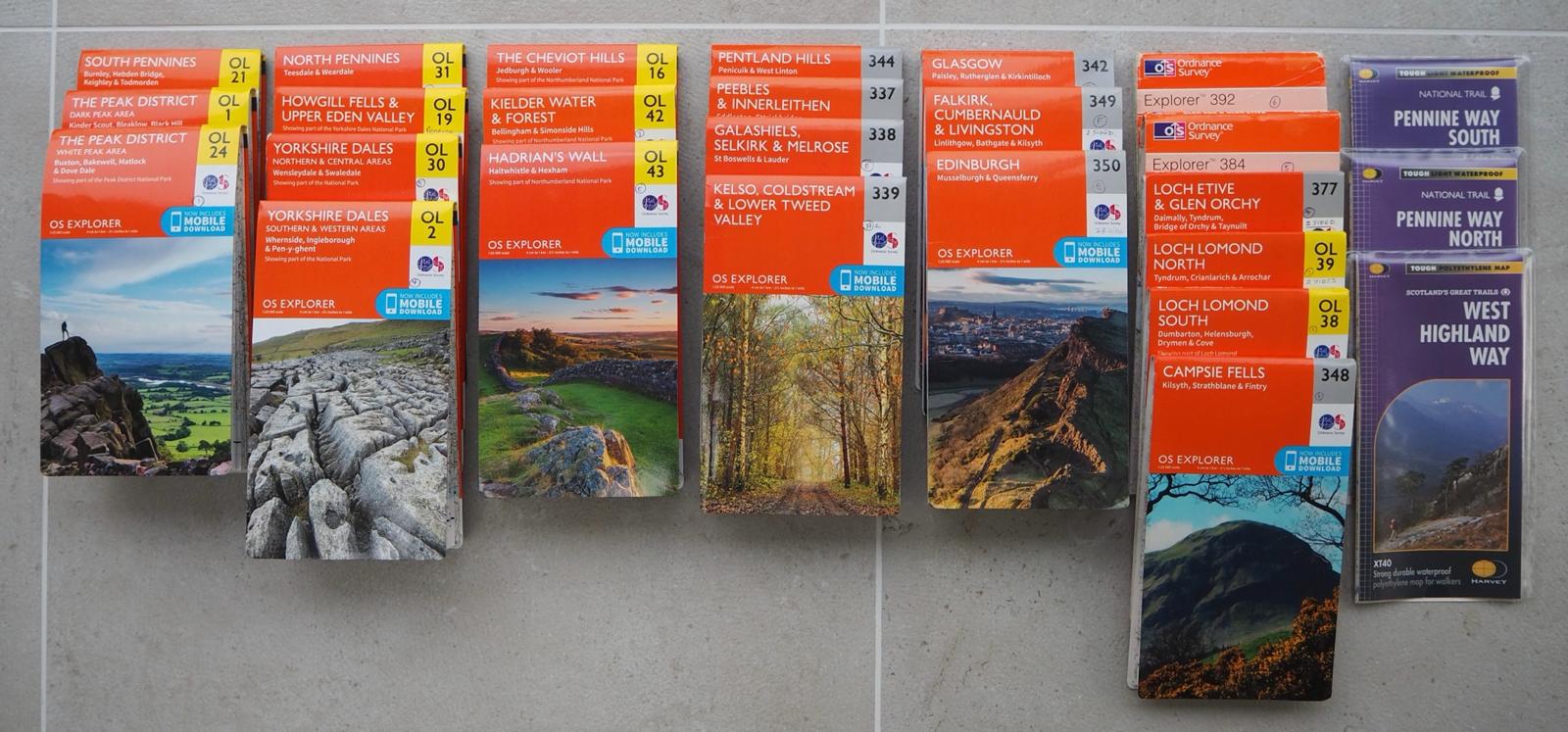
23 Ordnance Survey Maps! Paper versions in the first instance
Great Walks, The Pennine Way - Frank Duerden
Wainwright on The Pennine Way
Pennine Way - Stuart Greig & Bradley Mayhew
Pennine Panorama - Petre Wightman
Epic British Walks - Ordnance Survey
West Highland Way - Charlie Loram & Henry Stedman
Walking The West Highland Way - Terry Marsh, Cicerone
Scotland End to End - Cameron McNeish
The Living Mountain - Nan Shepherd
Feet in the Clouds - Richard Askwith
And a recent Christmas present…
Walking The Bones of Britain - Christopher Summerville
3D map supplied by Georges Maps
Wikipedia & Google of course
Booking.com and Trip Advisor
(Just for my own inspiration)
One Year on A Bike - From Amsterdam to Singapore - Martijn Doolaard
Mad, Bad and Dangerous to Know - Ranulph Fiennes
Ken Heptonstall
Ask me a Question?
Email kenh@headland.co.uk
I will try and help with any questions wherever possible.
Please use the subject line ‘The Northern Trek’.
My Background :-
Married with two children
Born in Leeds
Lived in York and Ilkley
Now lives in Southwell, Nottinghamshire
Career - worked in design, print, television and multimedia
Managing Director of Headland for 32 years
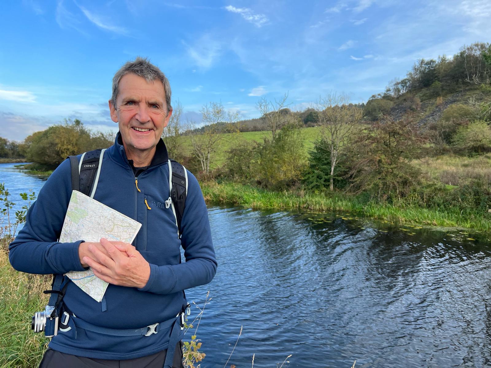
I’ve always loved hiking and the great outdoors.
I started walking in my early twenties and spent most weekends in The Lake District. My three summers whilst at college were an indication of my early interest in the ‘Big Walk’. 5 weeks in Norway, 5 weeks in the Dolomites, 2 weeks on the Tour de Mont Blanc.
I wrote my 10,000 word final essay on Hiking & Backpacking, to the bemusement of my tutors.
I have walked extensively in the subsequent years, particularly in Yorkshire and Derbyshire, Northumberland and The Lake District. Norfolk has a wonderful coastal footpath too.
I have completed many long distance footpaths in the UK and Europe.
My hobbies are photography, birdwatching, travel and whisky.
But not necessarily in that order.
I have always wanted to put something back into the world of Hiking and Backpacking - it has given me some wonderful memories.
The Northern Trek.
The Trek has received many plaudits in it's first year. Including a major feature in the i Newspaper Online (2024 Newspaper of the Year) and a double page spread in the Scotsman
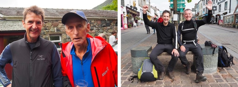
I would like to thank several friends who have helped me with The Northern Trek. Especially friends who 'physically' walked the route with me - in all weathers.
If it’s in the diary - we’re going.
Steve Woulds - Steve has produced the GPX mapping files for The Northern Trek and worked out the heights climbed and distance for each section. I couldn't have done it without him. Together we completed The Pennine Way, Edinburgh sections and Derbyshire’s 9 Edges. We have been walking together for over 40 years.
Download Backpacking the Tour du Mont Blanc with Pete Nightingale and Stephen Woulds
Mike Wasling - We walked from Kirk Yetholm to Edinburgh. For both of us, it was our first walk in the Pentland Hills. We also walked the 9 Edges in Derbyshire. Mike produced the video ‘fly through route’ for the entire 560 miles! Mike's a seasoned walker and has completed many of the UK's big walks.
Martin Dean - We've been great friends and work colleagues for over 30 years. Martin and I just beat off storm Babet on the Edinburgh to Milngavie stage.
Jules Von Hep - My son and I walked The West Highland Way together. We talked, laughed and drank. From Milngavie to the top of Ben Nevis.
My wonderful wife Shelagh - Together, we have re-visited, walked and checked several sections of the route.
Nicholas Heptonstall - We had a couple of wonderful weeks walking long stretches of the Scottish Highlands and at our second attempt got to the summit of ‘The Ben’.
Jim Brogden - Helped me rediscover the wonderful Central Pennines and northern canals. Jim christened the phrase for me, "Walk and talk".
James Hewlings - It's great walking with James for those lovely 'Hamlet' moments. We've trekked together in both The Yorkshire Dales and Pennines.
Richard Chalmers - We have walked regularly together for a decade in the Derbyshire Dales. We walked The Viking Way and have recently finished the South Downs Way (2024).
Pete Nightingale - We hiked together in Europe. Norway, Italy and the Alps in our early twenties. And we are still walking together, some forty years later.
Download Backpacking and Walking in Northern Italy with Pete Nightingale
And to all my family and friends who I have walked with over the years.
George’s Maps - Thank you for allowing me to use the 3D background map of the UK.
A couple of friends and colleagues from Headland, who have worked wonders on the design and web build.
Dave Watson Designed the site - www.gridpattern.co.uk
Craig Pickles Built the site and CMS - www.yorkshiretechy.co.uk
A team effort. Thank you.
I am very very grateful.